|
Moraine State Park (Lake Arthur) Bike Trail |
one moment while we fetch a trail picture
|
|
|
Moraine State Park (Lake Arthur) Bike Trail |
one moment while we fetch a trail picture
|
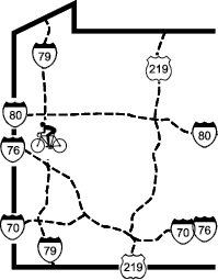
Vicinity: Directions begin on either US422 or I79 headed toward Moraine State Park. Details depend on which direction you are coming from.
Lake Arthur (bicycle rental concession) (western) trailhead:
From the east: Approach the park headed west on US422. About a mile after crossing the lake (and just before the I79 intersection), take the “North Shore” exit from US422. Go a quarter-mile to the “T” intersection with North Shore Dr. Turn right/north and follow signs for 0.8 miles to the bicycle concession and trailhead parking.
From the south: Approach the park headed north on I79. Take the PA488 exit (Portersville, Exit 28) and turn left/west. Go 0.6 miles to US19 in Portersville. Turn right/north on US19, go 0.5 miles, and turn right/northeast on SR4007 (West Park Rd, also numbered TR890). Follow signs for “North Shore Moraine State Park”. Go 2.8 miles on SR4007, crossing I79, US422, and Muddy Ck. Just after crossing the creek, turn right/west and follow signs 0.8 miles to the bicycle concession and parking.
From the west: Approach the park headed east on US422. Turn right/south on US19, go a bit over half a mile to Burnside Rd and turn left/west. Follow Burnside Rd just over a mile to SR4007 (West Park Rd) and turn left/north. Go 0.5 miles on SR4007, crossing US422 and Muddy Ck. Just after the creek crossing, turn right/west and follow signs 0.8 miles to the bicycle concession and trailhead parking.
From the north: Approach the park headed south on I79. Take the US422 exit (Exit 29). Turn right/west and go 1.2 miles to US19 and turn left/south on US19, then proceed as if coming from the west.
Other access: Since the trail lies between North Shore Dr and the lake, practically any parking lot along North Shore Dr provides access, especially the ones at lakeside.
Davis Hollow (eastern) trailhead: Instead of turning into the bicycle concession parking area, continue on the access road, which becomes North Shore Dr. After Mt Union Rd, take the first right/southeast turn and go to the building (a former restaurant, now (2018) the Moraine Outdoor Center) at the end. The trail is just to the right of the building.
Moraine State Park (Lake Arthur) Bike Trail - Access Points
Vicinity: Directions begin on either US422 or I79 headed toward Moraine State Park. Details depend on which direction you are coming from.
Lake Arthur (bicycle rental concession) (western) trailhead:
From the east: Approach the park headed west on US422. About a mile after crossing the lake (and just before the I79 intersection), take the “North Shore” exit from US422. Go a quarter-mile to the “T” intersection with North Shore Dr. Turn right/north and follow signs for 0.8 miles to the bicycle concession and trailhead parking.
From the south: Approach the park headed north on I79. Take the PA488 exit (Portersville, Exit 28) and turn left/west. Go 0.6 miles to US19 in Portersville. Turn right/north on US19, go 0.5 miles, and turn right/northeast on SR4007 (West Park Rd, also numbered TR890). Follow signs for “North Shore Moraine State Park”. Go 2.8 miles on SR4007, crossing I79, US422, and Muddy Ck. Just after crossing the creek, turn right/west and follow signs 0.8 miles to the bicycle concession and parking.
From the west: Approach the park headed east on US422. Turn right/south on US19, go a bit over half a mile to Burnside Rd and turn left/west. Follow Burnside Rd just over a mile to SR4007 (West Park Rd) and turn left/north. Go 0.5 miles on SR4007, crossing US422 and Muddy Ck. Just after the creek crossing, turn right/west and follow signs 0.8 miles to the bicycle concession and trailhead parking.
From the north: Approach the park headed south on I79. Take the US422 exit (Exit 29). Turn right/west and go 1.2 miles to US19 and turn left/south on US19, then proceed as if coming from the west.
Other access: Since the trail lies between North Shore Dr and the lake, practically any parking lot along North Shore Dr provides access, especially the ones at lakeside.
Davis Hollow (eastern) trailhead: Instead of turning into the bicycle concession parking area, continue on the access road, which becomes North Shore Dr. After Mt Union Rd, take the first right/southeast turn and go to the building (a former restaurant, now (2018) the Moraine Outdoor Center) at the end. The trail is just to the right of the building.