|
Moraine State Park (Lake Arthur) Bike Trail |
one moment while we fetch a trail picture
|
|
|
Moraine State Park (Lake Arthur) Bike Trail |
one moment while we fetch a trail picture
|
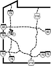
The designated bicycle trail in Moraine State Park runs on the north and west sides of Lake Arthur, generally between North Shore Dr and the lake. Two very different segments start at the parking lot near the bicycle concession at the northwest corner of the lake. Unlike most of the trails in this guide, these trails wind in and out of trees and up and down small hills. The well-known paved path runs for 7.2 miles to Davis Hollow Marina. An unpaved path runs along the west edge of the lake to Muddy Ck, then west to I79 for a total of 1.25 miles.
The 10-foot wide paved trail segment begins at the parking lot beside the bicycle concession. It follows the lake clockwise (north and east) for 7.2 miles to Davis Hollow Marina. It starts out alongside North Shore Dr but soon swings away into the woods with broad curves, rolling hills, and occasional views of the lake. After MP3, signs of park activity appear: boating, picnicking, swimming, disc golf, group camping and the parking lots and access roads that support them. The swimming area is near the parking lot at mile 3.7, as is the disc golf course. The sailboat storage and launch area is around mile 4.8. At MP5 the trail enters the woods again for more twists and turns to Davis Hollow marina where at mile 7.2, it emerges next to the building that formerly housed the Marina restaurant and is now (2025) the Moraine Outdoor Center.The trail is lovely, but the price of the winding trail is an assortment of tight curves, short hills, and poor sight lines. The trail is very popular, so it will have lots of activity any time during the season. It is possible that someone may be standing (once we encountered someone sitting) in the middle of the trail just around a blind corner. Alertness and speed control are required, but not always demonstrated by all trail users.
The unpaved segment of the trail is more intimate than the paved trail; it’s about 6 foot wide on crushed limestone. This trail also starts at the parking lot beside the bicycle concession, on the lake side of the parking lot where the North Country Trail comes out of the woods (foot traffic only in that direction). The North Country Trail and the bike trail share a crushed limestone path for a mile to a bridge across Muddy Ck. The bike trail follows the lake counterclockwise (south and west) to Muddy Ck and then follows Muddy Ck to the western park boundary. Unfortunately, the surface on the hills is often eroded, so the bike handling can be tricky.

From the parking lot the trail begins in open woods with wildflowers and passes the butterfly trail before crossing the McDanels Launch Area road at 0.7 mi. At this point the trail really shows the results of neglect. Sometimes the crushed limestone surface is just 6 feet wide. On some hills, there is no limestone, just rutted gravel. At McDanels Launch Area the trail enters woods above a creek, and descends for 0.3 miles to a bridge that carries the US422 off-ramp across Muddy Ck. This section of the Moraine Bike Trail is a pretty trail, but it requires a lot better bike-handling skills than most trails in this book.

The trail passes many recreation areas, including the marina
| Location | Moraine State Park, Butler County | ||
| Trailheads | Lake Arthur bicycle concession, Davis Hollow marina | ||
| Length, Surface | 8.4 miles total (7.2 paved, 1.25 crushed limestone) | ||
| Character | Busy, park setting, mostly sunny, | ||
| Usage restrictions | Snowmobiles okay on paved trail in season, | ||
| Amenities | Rest rooms, water, bike rental, food, fishing | ||
| Driving time from Pittsburgh | 0 hours 47 minutes |